If you are an adventurer and a hiker, you like to visit gorgeous places that are not invaded by civilization and tourism, Achibueno Lake is the best place in the area. The lake is only accessible on foot or on horseback. The round trip will take you several days, but in the end, it will be worth it.
Basic information
The Achibueno Lake is located in the Andean mountain range, close to Linares, in the Chilean Central Valley. This whole area is part of the Nature Sanctuary of River Achibueno. The lake is formed from melted snow and ice and it is the source of the Achibueno River. It is situated at an altitude of approximately 1800 meters (5900 feet) above the sea level, and 31 kilometers (19 miles) from Monte Oscuro, the last town accessible by a vehicle. The round trip takes between 2-5 days depending on your physical shape, your pace and the time you have.
The hike is of medium difficulty, climbing 1000 meters (3300 feet) from starting to end altitude. It is ideal for those who want to disconnect, surround themselves with nature, bathe in the river and the lakes, and observe the native flora and fauna; and perhaps talk with the muleteers who frequent the area (they raise goats ). The route passes through native forests of hualo trees (Nothofagus glauca) and cypresses, along the edge of the Achibueno river. If you are lucky, you can see the Andean condor, pudús (small South American deer), wild hares, foxes, and cougars.
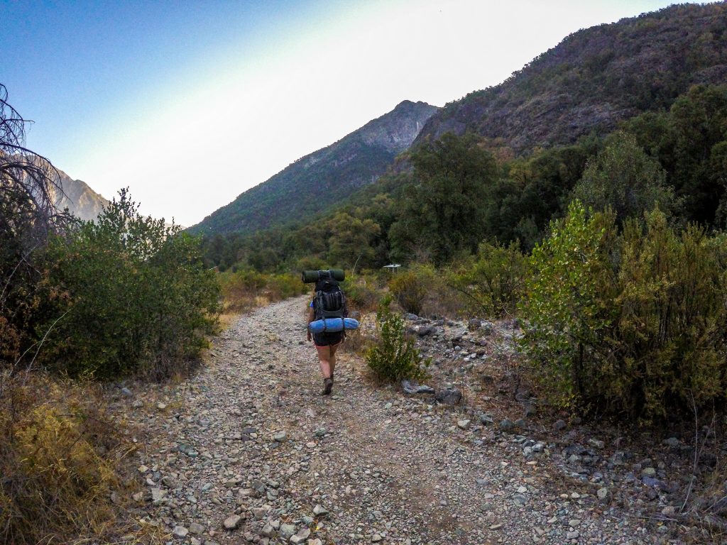
Photo credits: https://www.instagram.com/jorgeignaciolastra/
The Route
This hike begins in the sector called Monte Oscuro at the end of the road L-45 where you need to leave the car. The parking lot is marked by a sign that warns you that the road beyond is only accessible by a 4*4 vehicle. There is a tourist information center settled in a container. You will need to sign- in with the personnel and they can give you useful information for the hike, and they will show you the route on the map if needed.
On the route you have to cross several creeks, sometimes with the need to cross on foot and get wet, other times through wooden bridges. You pass through a place called the Mystic Circle; where at one end you can see the Achibueno waterfall and at the other end the Añintunes Lake waterfall. Those who have time and desire can make a detour and get to know Añintunes Lake as well.
What to Bring
You must bring the complete trekking equipment: tent, sleeping bag, stove, poles, trekking boots. As well as food for all the stay, a water bottle (you will fill from the river), sunscreen, repellent, sunglasses, etc. There are NO services on the route, so you need to bring all that you might need. Also, there will be no cellphone service at all on the route.
How to get there
The best option to get to the starting point of the hike is by car, as there is no public transport that gets there. You need to get to Linares (300 kilometers, 186 miles south from Santiago), then take the route L-45 towards the mountains (precordillera). Follow this route until the very end of it, approximately 60 kilometers (37 miles). You will encounter the river from the 14th kilometer (9 miles) onwards. The road is paved until 20th kilometer (12 miles), then it’s a dirt road. It is usually in good condition, all kinds of cars are able to transit with caution. However, towards the end of the road, it can get more difficult. To our amazement, we saw small city cars in Monte Oscuro that were able to get there.
You will pass various small sectors as Pejerrey (kilometer 31; 19 miles), the rural police station where you might need to sign-in at 36th kilometer (22 miles), Vado Azul (kilometer 48; 30 miles). After the police station, the road will divide, you need to go left. If on the way you still need to buy something small, Pejerrey would be the best option. Definitely, it would be best to bring all essentials with you. Bring cash for the whole stay, as there is no way to pay by card anywhere.
By bus
If you need to use public transport, you can get to Linares by bus or train from Santiago. Then, in the low season, there is only one bus daily that goes up from Linares bus station at 16.40 (Monday-Saturday). You will need to get off at the police station on the 36th kilometer. After that you will have to walk or hitch-hike the rest of the way (24 kilometers). In the low season, it might be difficult to get a ride, as very few cars will go up. In the summer months (January, February) there are more private bus companies that will go up during the day, but every year the schedule changes.
Time of the year
The access to the lake is open year-round, but depending on the road conditions, it might be impossible to get there in the winter if there is too much snow. I would definitely recommend going in the spring or autumn to avoid the heat of the summer and the cold of the winter.
Accommodation
During the hike, you need to use your tent as there is no accommodation on the way, but if you wish to stay in the area, swim in the river and relax before or after the hike, you are welcome to book your stay in our Aguapiedras cabins in Pejerrey.